Fayl:Northern Mali conflict.svg
Naviqasiyaya keç
Axtarışa keç

Bu SVG-faylın PNG formatındakı bu görünüşünün ölçüsü: 629 × 600 piksel. Digər ölçülər: 252 × 240 piksel | 503 × 480 piksel | 805 × 768 piksel | 1.074 × 1.024 piksel | 2.148 × 2.048 piksel | 1.316 × 1.255 piksel.
Faylın orijinalı (SVG faylı, nominal olaraq 1.316 × 1.255 piksel, faylın ölçüsü: 796 KB)
| Bu fayl "Vikimedia Commons"dadır və digər layihələrdə istifadə edilə bilər. |
 |
Faylın təsvir səhifəsinə get |
Xülasə
| İzah |
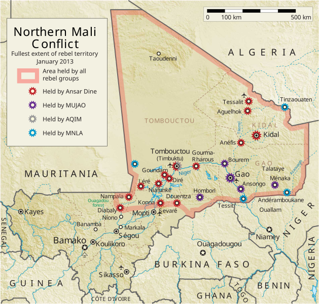
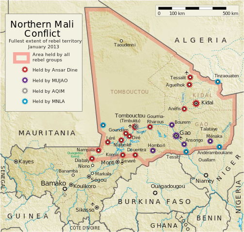
English: Map of the conflict in Northern Mali. (English)
العربية: خريطة الصّراع في شمال مالي. (إنجليزي)
Français : Carte du conflit au nord du Mali. (Anglais)
Latina: Charta rebellionis Tuaregorum in Malia septentrionali. (Anglice)
Українська: Карта конфлікту на півночі Малі. (Англійською) |
| Mənbə |
Öz işi This vector image includes elements that have been taken or adapted from this file: This vector image includes elements that have been taken or adapted from this file: |
| Müəllif | Orionist |
| Digər versiyalar | German/Deutsch/Allemand, French/Français, Macedonian/македонски јазик/Macédonien |
| SVG genesis |
Notes
- ↑ US Department of State, "Country Reports on Terrorism 2011", Chapter 2 Country Reports: Africa Overview, 31 July 2012
Lisenziya
I, the copyright holder of this work, hereby publish it under the following license:
Bu fayl Creative Commons Attribution-Share Alike 3.0 Unported lisenziyası altında yayımlanır.
- Azadsınız:
- paylaşmaq – əsəri köçürmək, paylamaq və ötürmək üçün
- remiks etmək – əsəri adaptasiya etmək
- Aşağıdakı şərtlərə riayət etməklə:
- istinad – Müvafiq kredit verməlisiniz, lisenziyaya bir keçid verməlisiniz və dəyişikliklərin olub olmadığını bildirməlisiniz. Bunu hər hansı bir ağlabatan şəkildə edə bilərsiniz, ancaq lisenziyalaşdırıcının sizi və ya istifadənizi təsdiqləməsini təklif edən bir şəkildə deyil.
- bənzər paylaşma – Əsəri remix edirsinizsə, dəyişdirirsinizsə və ya üzərində iş aparırsınızsa, öz töhfələrinizi orijinalda olduğu kimi eyni və ya uyğun lisenziya altında yayımlamalısınız.
Faylın tarixçəsi
Faylın əvvəlki versiyasını görmək üçün gün/tarix bölməsindəki tarixlərə klikləyin.
| Tarix/Vaxt | Kiçik şəkil | Ölçülər | İstifadəçi | Şərh | |
|---|---|---|---|---|---|
| 14:16, 31 mart 2012 |  | 1.315 × 1.254 (728 KB) | GeoEvan | Rebels have seized Bourem and Ansongo (http://bit.ly/Ht4bI0); enlarged Kidal starburst in proportion to size of city symbol; updated "as of" date | |
| 15:26, 30 mart 2012 |  | 1.315 × 1.254 (728 KB) | Mnmazur | Kidal in rebel control 30 March: http://www.bbc.co.uk/news/world-africa-17562066 | |
| 13:46, 29 mart 2012 |  | 1.315 × 1.254 (727 KB) | GeoEvan | (Fixing a couple text size and placement errors. Sorry.) | |
| 13:33, 29 mart 2012 |  | 1.315 × 1.254 (726 KB) | GeoEvan | Anefis captured by MNLA, Diré and Goundam overrun by MNLA but may not have been held onto (current situation unknown). | |
| 09:10, 15 mart 2012 |  | 1.315 × 1.254 (719 KB) | GeoEvan | Tessalit captured by MNLA, for serious this time | |
| 09:08, 15 mart 2012 |  | 1.315 × 1.254 (719 KB) | GeoEvan | Tessalit captured by MNLA, for serious this time | |
| 15:54, 29 fevral 2012 |  | 1.315 × 1.254 (719 KB) | GeoEvan | Not sure why the date text is slipping so far to the right. One last attempt at fixing it. | |
| 15:49, 29 fevral 2012 |  | 1.315 × 1.254 (719 KB) | GeoEvan | Small adjustment to date text | |
| 15:29, 29 fevral 2012 |  | 1.315 × 1.254 (721 KB) | GeoEvan | Clarify and distinguish which towns are and previously were under MNLA control, plus some other small tweaks. I made this version for my own site (http://polgeonow.blogspot.com), but thought the improvements might be appreciated here as well. | |
| 23:15, 20 fevral 2012 |  | 1.316 × 1.255 (675 KB) | Orionist | {{Information |Description ={{en|1=Map of the Tuareg rebellion in Azawad, Northern Mali showing rebel attacks as of 20 February 2012.}} |Source ={{own}} |Author =Orionist |Date = |Permission = |other_vers |
Fayl keçidləri
Aşağıdakı səhifə bu faylı istifadə edir:
Faylın qlobal istifadəsi
Bu fayl aşağıdakı vikilərdə istifadə olunur:
- af.wikipedia.org layihəsində istifadəsi
- ar.wikipedia.org layihəsində istifadəsi
- azb.wikipedia.org layihəsində istifadəsi
- bg.wikipedia.org layihəsində istifadəsi
- bn.wikipedia.org layihəsində istifadəsi
- ca.wikipedia.org layihəsində istifadəsi
- cs.wikipedia.org layihəsində istifadəsi
- cy.wikipedia.org layihəsində istifadəsi
- da.wikipedia.org layihəsində istifadəsi
- de.wikipedia.org layihəsində istifadəsi
- el.wikipedia.org layihəsində istifadəsi
- en.wikipedia.org layihəsində istifadəsi
- Mali
- Portal:Mali
- Insurgency in the Maghreb (2002–present)
- War on terror
- User:Orionist/Gallery
- National Movement for the Liberation of Azawad
- Wikipedia talk:WikiProject Maps/Archive 2012
- Wikipedia:In the news/Candidates/April 2012
- Wikipedia:Graphics Lab/Map workshop/Archive/Apr 2012
- Wikipedia:Wikipedia Signpost/2012-04-30/WikiProject report
- Wikipedia:Wikipedia Signpost/Single/2012-04-30
- Mali War
- Wikipedia:WikiProject Maps/Conventions/Pushpin maps
- Operation Serval
- Chadian intervention in northern Mali
- Islamist insurgency in the Sahel
- User:AlbanianEditor1990/sandbox
- en.wikinews.org layihəsində istifadəsi
- eo.wikipedia.org layihəsində istifadəsi
- es.wikipedia.org layihəsində istifadəsi
- et.wikipedia.org layihəsində istifadəsi
- eu.wikipedia.org layihəsində istifadəsi
- fi.wikipedia.org layihəsində istifadəsi
- fr.wikiquote.org layihəsində istifadəsi
Bu faylın qlobal istifadəsinə baxın.