Fayl:Colonisation2.gif

Faylın orijinalı (1.849 × 810 piksel, fayl həcmi: 2,08 MB, MIME növü: image/gif, ilmələnib, 12 çərçivə, 48 s)
| Bu fayl "Vikimedia Commons"dadır və digər layihələrdə istifadə edilə bilər. |
 |
Faylın təsvir səhifəsinə get |
Xülasə
| İzah |
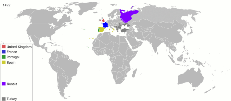
English: Map indicating the territories colonized by the European powers, United States and Japan.
Русский: Карта с указанием территорий, колонизированных Европейскими державами, Соединёнными штатами и Японией.
|
||||||||||||||||
| Tarix | 23 iyun 2008 (original upload date) | ||||||||||||||||
| Mənbə | Transferred from en.wikipedia to Commons. | ||||||||||||||||
| Müəllif | ArdadN at ingilis Vikipediya | ||||||||||||||||
| Digər versiyalar |
The maps can be seen separately by using this template:
Derivative works of this file: |
||||||||||||||||
.gif)
.jpg)
._LOC_2001620596.jpg)
Lisenziya
| Mən, bu əsərin müəllif hüquqlarının sahibi kimi, əsəri ictimai mülkiyyətə verirəm. Bu icazə bütün dünyada qüvvədədir. In some countries this may not be legally possible; if so: Bunun qanunla mümkün olmadığı hallarda: İstənilən şəxsə, istənilən məqsəd üçün, qanunlar tərəfindən qadağan edilməyincə, heç bir şərt qoymadan bu işdən istifadə haqqını bağışlayıram. |
Faylın tarixçəsi
Faylın əvvəlki versiyasını görmək üçün gün/tarix bölməsindəki tarixlərə klikləyin.
| Tarix/Vaxt | Miniatür | Ölçülər | İstifadəçi | Şərh | |
|---|---|---|---|---|---|
| 17:05, 15 sentyabr 2010 |  | 1.425 × 625 (257 KB) | NordNordWest | minor corrections | |
| 13:00, 18 mart 2009 |  | 1.425 × 625 (303 KB) | Yelm | {{Information |Description={{en|Map indicating the territories colonized by the European powers, United States and Japan.}} |Source=Transferred from [http://en.wikipedia.org en.wikipedia] |Date=2008-06-23 (first version); 2007-01-28 (last version) |Author | |
| 02:06, 2 aprel 2007 |  | 1.425 × 625 (295 KB) | Roke~commonswiki | comment about mongolia not being part of russia, take out 'adgif' aswell | |
| 14:52, 25 mart 2007 |  | 1.425 × 625 (309 KB) | Roke~commonswiki | from wikipedia with the same name, by Andrei nacu Map indicating the territories colonized by the European powers and the United States since 1660 {{PD-User|Andrei nacu}} Category:Animated maps of the world |
Faylın istifadəsi
Aşağıdakı səhifə bu faylı istifadə edir:
Faylın qlobal istifadəsi
Bu fayl aşağıdakı vikilərdə istifadə olunur:
- ar.wikipedia.org layihəsində istifadəsi
- av.wikipedia.org layihəsində istifadəsi
- azb.wikipedia.org layihəsində istifadəsi
- ba.wikipedia.org layihəsində istifadəsi
- be-tarask.wikipedia.org layihəsində istifadəsi
- be.wikipedia.org layihəsində istifadəsi
- bg.wikipedia.org layihəsində istifadəsi
- bn.wikipedia.org layihəsində istifadəsi
- bn.wikibooks.org layihəsində istifadəsi
- ce.wikipedia.org layihəsində istifadəsi
- cs.wikipedia.org layihəsində istifadəsi
- da.wikipedia.org layihəsində istifadəsi
- de.wikipedia.org layihəsində istifadəsi
- diq.wikipedia.org layihəsində istifadəsi
- en.wikipedia.org layihəsində istifadəsi
- History of Europe
- Early modern period
- Maritime history
- Colonial empire
- History of colonialism
- User:Palaeovia
- Portal:Maps/Maps/World
- Portal:Maps/Maps/World/18
- History of globalization
- User talk:AtomAtom
- Western world
- User:Meclee/proj4-sandbox
- User:Kazkaskazkasako/Books/History
- Outline of globalization
- Decoloniality
- Wikipedia:Graphics Lab/Map workshop/Archive/Apr 2014
- User:Bongan
- User:Bongan/genetic history of the human race
Bu faylın qlobal istifadəsinə baxın.