Fayl:History of NATO enlargement.svg
Naviqasiyaya keç
Axtarışa keç

Bu SVG-faylın PNG formatındakı bu görünüşünün ölçüsü: 512 × 394 piksel. Digər ölçülər: 312 × 240 piksel | 624 × 480 piksel | 998 × 768 piksel | 1.280 × 985 piksel | 2.560 × 1.970 piksel.
Faylın orijinalı (SVG faylı, nominal olaraq 512 × 394 piksel, faylın ölçüsü: 592 KB)
| Bu fayl "Vikimedia Commons"dadır və digər layihələrdə istifadə edilə bilər. |
 |
Faylın təsvir səhifəsinə get |
Xülasə
| İzah |
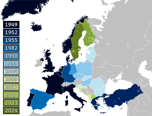
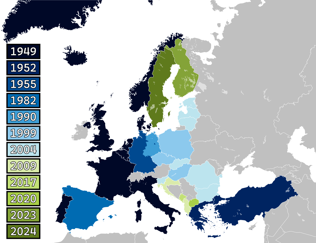
Dansk: Kort over NATOs historiske udvidelser i Europa. Esperanto: Mapo de la historia ekspansio de NATO en Eŭropo. Polski: Mapa historycznej ekspansji NATO w Europie. Suomi: Kartta Naton historiallisesta laajentumisesta Euroopassa. Svenska: Karta över Natos historiska expansion i Europa. Türkçe: NATO'nun Avrupa'daki tarihsel genişlemesinin haritası. |
| Tarix | |
| Mənbə | Own work based on: Blank map of Europe (with disputed regions).svg by maix və Alphathon |
| Müəllif | Patrickneil və Spesh531 |
| Digər versiyalar | NATO expansion.png, History of NATO enlargement animation.gif |
| SVG genesis | This map was created with Adobe Illustrator. |
.svg)
Lisenziya

|
Bu sənədi GNU Azad Sənədləşdirmə Lisenziyası, Versiya 1.2 və ya Azad Proqram Fondu tərəfindən nəşr olunan hər hansı sonrakı versiya şərtlərinə əsasən dəyişməz bölmələr, ön qapaq mətnləri və arxa qapaq mətnləri olmadan köçürmək, yayımlamaq və / və ya dəyişdirmək üçün icazə verilir; Lisenziyanın bir nüsxəsi GNU Azad Sənədləşdirmə Lisenziyası adlı hissəyə daxil edilmişdir. |
| Bu fayl Creative Commons Attribution-Share Alike 3.0 Unported lisenziyası altında yayımlanır. | ||
| ||
| This licensing tag was added to this file as part of the GFDL licensing update. |
Faylın tarixçəsi
Faylın əvvəlki versiyasını görmək üçün gün/tarix bölməsindəki tarixlərə klikləyin.
| Tarix/Vaxt | Miniatür | Ölçülər | İstifadəçi | Şərh | |
|---|---|---|---|---|---|
| 06:54, 8 mart 2024 |  | 680 × 520 (481 KB) | Ratherous | Reverted to version as of 19:11, 7 March 2024 (UTC) The problem with that version is not only in regards to the lakes. The borders are not as accurately drawn. The other template had more update and fixes | |
| 19:58, 7 mart 2024 |  | 512 × 394 (672 KB) | Patrickneil | here is a compromise with the lakes and colors for Ecrusized | |
| 19:11, 7 mart 2024 |  | 680 × 520 (481 KB) | Ecrusized | Reverted to version as of 17:39, 7 March 2024 (UTC) This just looks bad without the bodies of water. | |
| 18:15, 7 mart 2024 |  | 512 × 394 (621 KB) | Patrickneil | Reverted to version as of 15:21, 7 March 2024 (UTC) I rebuilt this SVG from a map of Europe that included fewer, though not zero, interal bodies of water. It isn't a geographic map, it is a political map. Let's discuss on the talk page. | |
| 17:39, 7 mart 2024 |  | 680 × 520 (481 KB) | Ecrusized | This actually removed the lakes and other bodies of water. | |
| 15:21, 7 mart 2024 |  | 512 × 394 (621 KB) | Patrickneil | adding Sweden, using suggested color scheme, and rebuilding SVG from scratch | |
| 14:47, 4 aprel 2023 |  | 680 × 520 (452 KB) | Einsamer Schütze | White numbers for better contrast | |
| 13:29, 4 aprel 2023 |  | 680 × 520 (452 KB) | Patrickneil | Upload failed, redoing and also reducing file size | |
| 13:24, 4 aprel 2023 |  | 680 × 520 (804 KB) | Patrickneil | to my eye, that dark red breaks the patter, but perhaps we can compromise on this shade of orage, which was used for Croatia and Albania in previous versions of this map | |
| 13:00, 4 aprel 2023 |  | 680 × 520 (804 KB) | Ecrusized | Changed into a more dominant and easier to look at color. The light yellow is hard to distinguish from the white background. |
Faylın istifadəsi
Aşağıdakı səhifə bu faylı istifadə edir:
Faylın qlobal istifadəsi
Bu fayl aşağıdakı vikilərdə istifadə olunur:
- af.wikipedia.org layihəsində istifadəsi
- be-tarask.wikipedia.org layihəsində istifadəsi
- bg.wikipedia.org layihəsində istifadəsi
- br.wikipedia.org layihəsində istifadəsi
- bs.wikipedia.org layihəsində istifadəsi
- ca.wikipedia.org layihəsində istifadəsi
- cs.wikipedia.org layihəsində istifadəsi
- cs.wikinews.org layihəsində istifadəsi
- da.wikipedia.org layihəsində istifadəsi
- de.wikipedia.org layihəsində istifadəsi
- de.wikinews.org layihəsində istifadəsi
- diq.wikipedia.org layihəsində istifadəsi
- el.wikipedia.org layihəsində istifadəsi
- en.wikipedia.org layihəsində istifadəsi
- NATO
- Warsaw Pact
- American imperialism
- Presidency of Bill Clinton
- Treaty on the Final Settlement with Respect to Germany
- Russia–European Union relations
- Russia–United States relations
- Revolutions of 1989
- Enlargement of NATO
- Talk:Second Cold War
- User:Jaydavidmartin/Second Cold War
- Controversy in Russia regarding the legitimacy of eastward NATO expansion
- User:Falcaorib/Europe
- eo.wikiquote.org layihəsində istifadəsi
- es.wikipedia.org layihəsində istifadəsi
- eu.wikipedia.org layihəsində istifadəsi
- fa.wikipedia.org layihəsində istifadəsi
- fi.wikipedia.org layihəsində istifadəsi
- fi.wikibooks.org layihəsində istifadəsi
- fr.wikipedia.org layihəsində istifadəsi
- fy.wikipedia.org layihəsində istifadəsi
- gl.wikipedia.org layihəsində istifadəsi
Bu faylın qlobal istifadəsinə baxın.