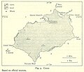
Fayl:Map of Cocos from Pacific Islands, vol. 2 (Geographical Handbook Series, 1943).jpg
Naviqasiyaya keç
Axtarışa keç
Map_of_Cocos_from_Pacific_Islands,_vol._2_(Geographical_Handbook_Series,_1943).jpg (646 × 555 piksel, fayl həcmi: 77 KB, MIME növü: image/jpeg)
Faylın tarixçəsi
Faylın əvvəlki versiyasını görmək üçün gün/tarix bölməsindəki tarixlərə klikləyin.
| Tarix/Vaxt | Kiçik şəkil | Ölçülər | İstifadəçi | Şərh | |
|---|---|---|---|---|---|
| indiki | 20:13, 12 oktyabr 2006 |  | 646 × 555 (77 KB) | Ratzer | http://www.lib.utexas.edu/maps/historical/pacific_islands_1943_1945/cocos.jpg http://www.lib.utexas.edu/usage_statement.html?maps=yes: "Most of the maps scanned by the University of Texas Libraries and served from this web site are in the public domain. |
| 20:12, 12 oktyabr 2006 |  | 646 × 555 (77 KB) | Ratzer | ||
| 20:09, 12 oktyabr 2006 |  | 646 × 555 (77 KB) | Ratzer | http://www.lib.utexas.edu/maps/historical/pacific_islands_1943_1945/cocos.jpg http://www.lib.utexas.edu/usage_statement.html?maps=yes: "Most of the maps scanned by the University of Texas Libraries and served from this web site are in the public domain. |
Fayl keçidləri
Aşağıdakı səhifə bu faylı istifadə edir:
Faylın qlobal istifadəsi
Bu fayl aşağıdakı vikilərdə istifadə olunur:
- bg.wikipedia.org layihəsində istifadəsi
- ca.wikipedia.org layihəsində istifadəsi
- cs.wikipedia.org layihəsində istifadəsi
- de.wikipedia.org layihəsində istifadəsi
- el.wikipedia.org layihəsində istifadəsi
- en.wikipedia.org layihəsində istifadəsi
- en.wikivoyage.org layihəsində istifadəsi
- eo.wikipedia.org layihəsində istifadəsi
- es.wikipedia.org layihəsində istifadəsi
- fr.wikipedia.org layihəsində istifadəsi
- gl.wikipedia.org layihəsində istifadəsi
- he.wikipedia.org layihəsində istifadəsi
- hr.wikipedia.org layihəsində istifadəsi
- ja.wikipedia.org layihəsində istifadəsi
- nn.wikipedia.org layihəsində istifadəsi
- no.wikipedia.org layihəsində istifadəsi
- pl.wikipedia.org layihəsində istifadəsi
- ru.wikipedia.org layihəsində istifadəsi
- sh.wikipedia.org layihəsində istifadəsi
- uk.wikipedia.org layihəsində istifadəsi
- vi.wikipedia.org layihəsində istifadəsi


